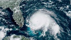

This GOES-16 satellite image taken Sunday, Sept. 1, 2019, at 17:00 UTC and provided by National Oceanic and Atmospheric Administration (NOAA), shows Hurricane Dorian, right, churning over the Atlantic Ocean. Hurricane Dorian struck the northern Bahamas on Sunday as a catastrophic Category 5 storm, its 185 mph winds ripping off roofs and tearing down power lines as hundreds hunkered in schools, churches and other shelters. (NOAA via AP)
